My first experience with a hurricane was while I was living in upstate New York, enrolled at Elmira College and working at Corning Hospital. Agnes traveled from the Gulf of Mexico through Florida, Georgia, and South Carolina, then out into the Atlantic to pick up more strength before coming into New York and Pennsylvania. It was a very early hurricane, and although not strong by wind speed standards, it created havoc by flooding rains -- over 7 inches in Elmira, NY. I was in Elmira when the floods hit on June 23, 1972. The river crested at over 25 feet, flood stage was 12 feet. The folks in Corning, NY, had been told, as they went to bed, not to worry, that the dikes would hold. My mother, who worked with the Red Cross, had phoned me at work the day before, warning me to get out of town, given what she knew was already going on upstream. The dikes in Corning (crested at almost 41 feet, flood stage was 29) collapsed, and a wall of water swept through the valley. Where I lived, in Elmira, the dikes did hold, but the water rose higher than they stood, so the flood waters came up slowly. They came up to within about 4 blocks from where we lived. That was a close call. It was weeks before we could get out of the county and back into Corning. I thought I would never have another experience with a flood like that. Agnes killed 129 people. Agnes, The Flood of '72 -- PBS documentary, 1 hour 8 minutes. Agnes, Corning, NY -- 10.5 minutes
Hurricane Diane made landfall near Wilmington, North Carolina. The center of the storm passed about 10 to 15 miles to the east of our home in Rountree (which was at 35.5 N, 77.5 W). Maximum sustained winds were about 50 mph. We suffered no loss to property.
Hurricane Charley ran across far eastern North Carolina, about 90 miles east of us, with maximum winds of about 80 mph. We suffered no loss to property.
Category 3 Hurricane Bob skirted the Outer Banks well east of us, with maximum winds of about 115 mph. We suffered no loss to property.
Category 3 Hurricane Emily skirted the Outer Banks well east of us, with maximum winds of about 115 mph. We suffered no loss to property.
Tropical Storm Allison pass about 40 miles to our southeast, with winds of about 45 mph. We suffered no loss to property.
We were under the gun in 1996. Tropical Storm Arthur skirted the North Carolina coast on the 20th of June. This was just a preview of what was to come.
I was in Switzerland with my wife and son when Bertha hit. Our daughter, Lotus, was home alone. Being in a big old house during a hurricane made quite an impression on Lotus. Early in the storm she went out in the back yard to pick up items that could blow away. The screen door locked itself (the hook fell into the hole) when it slammed, locking Lotus out of the house. She had to break her way in. The center of the hurricane passed about 15 miles to the east of our house in Rountree, with winds of about 75 mph. We suffered no property damage.
Fran caused a lot of wind damage (115 to 125 mph) here, and some flooding, (about a foot of rain) but nothing like what was to come in 1999. The center passed 60 to 70 miles southwest and west of us. Fran took out trees in our yard, including a pecan tree that landed on my daughter Lotus' car. The wind was so strong that it drove water through the walls of our old house. All we could do was sit and watch the water run down the wall and collect on the floor.
Tropical Storm Josephine passed abut 25 miles southeast of us, but was not very impressive after Fran.
Danny was only a minor nuisance here in eastern North Carolina. It pretty much blew its wad earlier, on Alabama. We only got 2 to 3 inches of rain from it. It passed about 25 miles west of us with winds of about 40 mph. Danny had weakened to a tropical depression over Alabama and Georgia but then strengthened to a tropical storm over North Carolina.
Bonnie came ashore near Jacksonville, NC, about 70 miles due south of us, with winds of 100 mph. It moved northeast, with the center passing about 40 miles east of us with 70 mph winds. It gave us about 8 inches of rain, but no major problems here in Pitt county.
Dennis and Floyd combined to give us a one-two punch. Dennis gave us about 8 inches of rain during an 8 day period late in August and early in September, saturating the soil. Dennis stalled off the coast as a hurricane for several days and then came in as a tropical storm, the center passing right over us on the 5th of September with winds of 40 to 50 mph.
Ten days after getting soaked by Dennis, on Sept. 16, 1999, Floyd delivered the knockout punch. It came in near Cape Fear, with winds of 105 mph. The governor announced that all state employees, excepting "critical" employees, were to be dismissed at 2 PM to go home and prepare for Floyd. Classes were dismissed, and the campus quickly emptied. I stayed to backup computer files and secure my office and the computer lab. When I tried to leave at 2:30, I was told that, as a member of the personnel committee, I was "critical" and would have to stay for its meeting. I objected, but stayed. I left for home at 3:30 and took an alternate route to avoid those areas which I know are the first to flood. Even on this route, I was lucky to get home. There was water on or flowing across the road on which I live, and cars off to the side, where they had skidded into the ditch or stalled from flooding.
Overnight we watched the news of Floyd on TV. I avoided the Weather Channel though, since I was still upset with them for having repeatedly said, while Floyd was headed west towards Florida, "we are all hoping it will turn north." Well, turn north it did, right into us! It generated numerous tornadoes. A little after 8 they announced that there was a tornado in Tuscarora and that it was headed towards Fort Barnwell and would be in Grifton by 8:30. I put a ruler on my map from Tuscarora to Fort Barnwell to Grifton and was distressed to see that Rountree (where I lived) was right on that straight line. Fortunately, the tornado (detected by radar) missed us or didn't touch down there.
Floyd was projected to pass close to us on our west, but fortunately for us it passed on our east instead (winds are generally worse on the east side of a hurricane). It did pass very close (near New Bern and little Washington), but had weakened somewhat by the time the strongest winds (80 mph) reached us, about 7 in the morning, when the real action started:
About 7:15 our cable went out. We hooked up the TV to the antenna instead.
About 7:30 our electric went out.
About 7:45 the gigantic old oak tree by the side porch fell. It did not make much noise. Earlier we had noticed that the water in Lake Rountree (our yard) was clear except by the base of that tree, where it was clay colored. Now we know that color was from the roots pulling up. The tree fell towards the road, not the house, thankfully. It missed our cars by a foot or two. It was quite a sight -- the base of the tree (roots and earth) formed a giant disk on its side about 12 feet high. The ground was so soft that branches on the down side just dug into the earth.
About 8:00 the pole in our yard to which our power line is secured snapped and went down. I had been watching it lean in the wind, and was watching it when it went down. The power line was draped over the felled oak tree and then ran on the ground to our house. It pulled the line and meter off of our house, but the line did not break. It was quite low running across the road to the transformer on the big post there. The winds also folded back one panel of the tin on our roof.
About 8:15 the middle (of three) tobacco barns on the west side of house went down. I heard it, but thought only a piece of its tin roof had blown off. The whole barn collapsed to the ground.
While I was relatively dry at home, East Carolina University's campus was flooding along Tenth Street. Click here for Photos of ECU Flooding.
Our relief at having survived the passing of the storm was followed by days of dread while rivers and creeks spilled over their banks and flooded large areas of eastern North Carolina. Contentnea creek, which runs nears our house, flooded large areas of adjacent Greene County, but stopped about a mile short of our house.
I spent over a week cleaning up our yard, much of which was covered by the enormous oak that fell. There were still many areas under water, and the damage to roads and bridges was great. East Carolina University got a little revenge when their football team upset the Miami Hurricanes in Raleigh. It was Miami's misfortune to play a team which had a grudge against hurricanes of any type. After beating the University of South Carolina in football, ECU's football team was stranded in Columbia, South Carolina, unable to get back to flooded Greenville. The next game was with the University of Miami (nationally ranked #9), and was to have been played in Greenville. The game was moved to Carter-Finley stadium in Raleigh. Behind 23-3 in the third quarter, ECU came storming back, scoring 24 unanswered points to win the game. After having been thrashed by Hurricane Floyd, we took special pleasure in coming back to defeat a powerful team known as "The Hurricanes."
The flood waters brought out one of my favorite plants, Lycoris radiata, also known as spider lilies, hurricane lilies, and naked ladies. These strange plants are nowhere to be seen until late summer or early Autumn, when they suddenly send up strange but beautiful flowers. The foliage follows later. The flood waters also brought many fire ants (ouch) and Dasymutilla occidentalis, cow killers to our yard. The female cow killer is an interesting and beautiful wingless wasp, whose sting is said to be very nasty.
In nearby Greenville, NC, the Greenville Utilities operations center was under water. It had been built in the flood plain on Mumford Road. Later they wised up and moved it to higher ground.
As if we hadn't already had enough flooding, on October, 17, 1999, Irene marched up to our doorstep and then turned away at the last moment -- but her rains caused renewed flooding. My son had a friend over to the house this day. He took his friend back home about 5 PM. I was worried that he might encounter flooded roads. He did manage to get his friend home, but when he tried to get back to our home, he found that all roads to our house were flooded out. We were on an island that evening.
The European branch of our family was not immune to hurricane force winds and flooding in 1999 either. The storms that hit western Europe with hurricane force winds in December of 1999 flooded my sister's house in France and caused damage to structures owned by our relatives and friends in Switzerland.
Kyle was a coast hugger, reduced to a tropical depression when it passed east of us, causing us no problems.
After Floyd, we decided it was time to move into a new house, one with no trees close to the house. In December of 1999 we bought a house not far from our old house. The new house had been built in 1997 and had suffered only minor damage (to screens, shingles, and decorative shutters) and no flooding with Floyd. We had three hurricane-free summers before Hurricane Isabel visited us in our new house. Hurricane Isabel was a category 5 monster when it became apparent that it was likely to strike the east coast. Lucky for us, it weakened to a strong category 2 hurricane before it visited us. The university closed at 2 PM on Wednesday the 17th. We had already been making preparations for the arrival of Isabel, but there are always last minute things to do. I stopped by my son's apartment (a junior at the university) on the way home and gave him a flashlight, batteries, and some hurricane cash. Having experienced hurricanes out in the county with us, he wanted to stay in town and see what it was like there. Before sunset we picked tomatoes, eggplants, and okra from our gardens, put my car in the garage, put cinder blocks against the front and side storm doors, removed the screens from the windows, and so on. We had strong winds Thursday morning, as Isabel approached the coast. We lost power about 11:30 that morning, got it back two hours later, and lost it again one hour later. The winds were not as strong as we expected, but we got a bit more rain than I had expected. The National Weather Service reported that the storm brought to my location sustained (two minute) winds of not more than 40 mph and peak gusts of a little more than 50 mph, at about 3 PM. Peak gusts were about 100 mph on the Outer Banks and some inland locations such as Plymouth, northeast of us. We got about 5 inches of rain in my section of Pitt County. We went out in the storm once on Thursday morning, to move a large branch that had fallen close to the doghouse. I also wired down the TV cable box on the side of the house, as the cover had blown off. We were not able to get out again until after the eye had passed north of us. The eye came over northeastern Pitt county, about 15 miles from us. The morning winds came from the north, and later rotated to northwest, west, and then southwest. When they came from the northwest they blew directly at the door to our deck and forced water under that door. The rain was horizontal at that time. The damage on our street was not bad. We watched the winds blow a metal storage shed into the font yard of one neighbor's yard, and feared that it would blow over into our yard and hit our cars, but it stayed put. The shed was flipped over on its roof, and the winds crushed the walls down against the roof, which reduced the surface area exposed to the winds. The neighbor on the other side lost a big Bradford pear tree, and other Bradford pears in the neighborhood were damaged too. Our house lost some shingles from the roof, as did our back door neighbor's house. Our biggest loss was a russet apple tree, which had just born fruit for the first time this year. The winds had blown it over and snapped the trunk a few inches below ground level. Our prune-plum tree was also blown over, but I
was able to stand it back up. Our swimming pool was full of debris as was the yard, so there
was a lot of cleaning up to do. My eldest daughter, Athena, and her family, were hunkered down in their condo about 8 miles from here, and my son, Sol, was out in the storm in Greenville. He
was majoring in Physical Geography, then taking a class in environmental hazards, and was hoping to see another natural disaster (like the flooding from Floyd). He stayed outside during the storm, but was very disappointed with it. The rest of us are quite pleased that it was not so bad. As with Floyd, the
Lycoris radiata made their first appearance in association with the storm. Hurricane Alex grazed the Outer Banks on the 3rd of August, 2004. I was in the hospital that morning, having some minor surgery. It did not affect us here in Pitt County. In fact, we had beautiful weather. On the 12th of August Tropical Storm Bonnie made landfall in the panhandle of Florida and then the remnants ran up through North Carolina, spawning a few tornados and dumping a couple of inches of rain on us. Hurricane Charley (Category 4) made landfall near Fort Meyers, FL, and then crossed the state to enter the Atlantic. It made a second landfall near the border between South Carolina and North Carolina as a Category 1 hurricane and then rapidly moved northeast, crossing right over us. At 11 AM on the 12th
of August Charley was at Latitude 33.2 N, 79.0 W (75 mph winds), at 2 PM it was
at 34.8 N, 77.9 W (70 mph), and at 5 PM it was at 36.0 N, 77.0 W (70 mph). My
house is at 35.49 North, 77.46 West. We got between 4 and 5 inches of rain in a short period of time and had wind gusts of about 40 mph. Charley moved through so quickly that it did not cause much damage. It did spawn some tornados and caused some flash flooding. The only damage at my place was that my prune plum tree was leaning more than before -- it was already leaning a bit from
the previous year's hurricane. I pulled it straight with some rope and a stake the next morning. The branch that runs along the border of my property was quite swollen and running fast, but did not come up all the way to my garden (but came close).
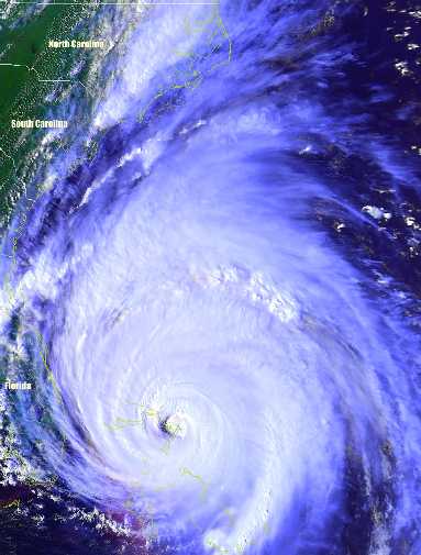
When the eye of Charley was over us I ran out on the deck and took
this photo. TS Gaston made landfall in South Carolina on the 29th of August and then passed through North Carolina. It stayed far enough west of us (near Raleigh) that it caused us no major problems. The winds did blow pine needles and bark and crepe myrtle flowers into our swimming pool, but we did not get a lot of rain.
My son, Sol, prepared a this map of the path these hurricanes took:
Hurricane Ophelia grazed the coast of North Carolina on
the 14th and 15th of September, 2005. Considerable damage was caused along
the coast, due to heavy rain and Ophelia's slow movement, but here in Pitt
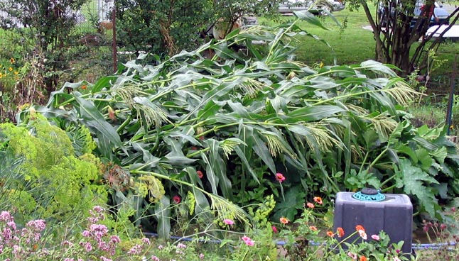
county we were happy to get the much needed rain, about two inches. The center of tropical storm Alberto passed thirty miles
to our west on the afternoon the the 14th of June. It was not
very impressive, but did lead to some storm damage and flooding. On my
drive home from the office I noticed fields of corn that were blown down.
I pretty much knew then what my garden would be like. When I got home I
found that everything was blown down, including
my corn.
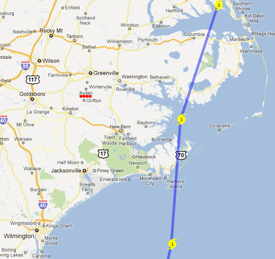
The center of tropical storm Ernesto
passed thirteen miles to our west in the early morning of the 1st of
September. It was quite impressive for a tropical storm, well organized
with lots of rain and strong winds. I took pictures of
flooding.
The center of tropical storm Hanna passed 35 miles to the west of us in the
early morning of the 6th of September. We had winds gusts up
around 60 mph and got a bit over an inch and a half of rain. Most of the
rain was on the west side of the storm, up near Raleigh.
The center of Hurricane Irene (aka "I rain" and "I blow") passed
69 miles to the east of us at about 17 GMT (1 PM
EDT) on Saturday the 27th of August. The sustained winds were
not that strong (about 40 mph), but there were hurricane force gusts.
Irene moved very slowly along the North Carolina coast, so we were pounded all
day long. When I went to bed (aka "passed out after drinking too much
bourbon) Friday night I was convinced that Irene would be only a rain event, and
there would be little wind damage. After all, she was only a category one
hurricane. I had not counted on her staying here all day long and
delivering so many strong gusts. I woke up at 7:30 Saturday
morning, to the sound of pouring rain. I peeked out the window and was
shocked at how far the trees were bending in the wind. I was just about to
boot up my computer and start breakfast when the power went out. It stayed
out almost 36 hours. My son, Sol, and daughter-in-law, Edali, got up soon
after that. Although they live in Greenville, they kindly came to stay
with us for the storm. Sol had brought a bunch of camping supplies,
including a portable propane grill, which he used to make us some coffee, with
the grill set up in the garage, with doors opened enough to provide adequate
ventilation. It was somewhat entertaining to watch the
winds whip the trees and blow debris around, but that got boring after several
hours. Without electric power and being stuck indoors cabin fever sets in
pretty quickly. Sol made us lunch and dinner from canned goods and
dehydrated meals he had bought for camping. We had hoped to grill some
meat for dinner on the big grill on the deck, but Irene was still dumping rain
and wind on us at nightfall. At one point in the afternoon I watched the
wind move that big grill a couple of feet, which surprised me. When the
rain and wind did let up later in the evening we went outside and set off all
the fireworks we had left from our celebration of the fourth of July and the
first of August (Swiss national day). Sunday was dreadful.
Hot, no air conditioning, no refrigeration, no TV, no Internet, no ceiling fans,
and lots of debris to clean up outside. A neighborhood teen came by with a
chainsaw and kindly cut up some of the large branches that had come down into
our front yard from our pine trees and the neighbor's maple tree -- the same
maple tree I was trimming last year when the ditch bank collapsed, throwing me
off the ladder and breaking my leg. Later I cut up the
larger branches with my chain saws. Sylvia was out
early Sunday morning, cleaning up tree debris. I was out later, but was
not able to stand the heat for long. Sol and Edali kindly cleaned up most
of the debris for us. For the third time in ten years, we lost our apple
tree, snapped off at the base. It seems the hurricane gods do not want us
to have homegrown apples. Our prune plum tree was also blown down, again
-- it was, I thought, securely staked, but the hurricane broke the heavy nylon
rope with which I had staked it. It has survived, barely, but did not give
us any plums in 2012. Sol and Edali
headed back home about mid-afternoon. Then I took a nap and after that I
went out to check my veggie garden. Many of the plants had been shredded
by the winds, but I found a tomato plant that was still intact, but blown down
into the mud. I re-staked it and did the same with my eggplants. My
cucuzza and many other plants
were wilted from being drowned.
When I came back in from the garden, about 7 PM, the electric power had just
been restored. If it had been out much longer, I would have lost the food
in our refrigerator and our freezer. After dinner (rabbit stew) I emailed to my
Farm Bureau insurance agent (Tony Boyd) photos of the
damage to our roofs. He responded almost immediately and initiated
a claim the next day. Tony is a first class agent. Here is
our new roof.
Hermine
transitioned from tropical storm to Category 1 Hurricane in the Gulf of Mexico
shortly before making landfall near the bend in northwestern Florida. It
moved through southern Georgia and then along the coast in South and North
Carolina and then back into the Atlantic. The storm passed over us during
the night of the 3rd. It was breezy, with gusts as high as 40 to 45 mph.
It was mostly a rain event. We got 5.5 inches of rain at our place.
Matthew trashed Haiti and then moved up the east coast
along Florida and the Carolinas, making landfall on Oct. 8 southeast of
McClellanville, South Carolina, as a Category 1 hurricane with 75 mph winds, but
not going far inland. We were counting on the projections that had it
going east, out to sea, before it got to us. No such luck.
Fortunately, I live not close to any rivers, but do have a branch on one side of
our property. The only wind damage we suffered at my place was one Rose of
Sharon shrub being blown over. It was more of a rain event than a wind
event, and we had already received a lot of rain in the days before Matthew
arrived. Matthew dumped about ten inches of rain at my place. My son
is a Geographic Information Systems manager for Pitt County (and a bit of a
weather nut, having studied climate change in graduate school at ECU). He
was called up for duty, day and night, at the Emergency Operations Center.
He and his colleagues prepared a nifty Google Maps app that showed road closures
throughout Pitt County.
In Greenville there was a lot of flooding both
around the Tar River. Many of my graduate students were living between campus and the
Tar river, and some of them had to evacuate. The University was closed for
a week and a day.
Florence was predicted to make landfall in
southeastern North Carolina as a Category 3 or 4 storm and then head northwest
near us. I made even more extensive preparations than usual. It came
in to Wrightsville Beach / Wilmington at 0715 on 14-September-2018 with
sustained winds of 90 mph. Lucky for us, but not for those south of us, it
moved westerly, and at a snail's pace, though southeastern North Carolina and
into South Carolina, then curving northerly into western North Carolina.
It exited North Carolina on 17-September-2018, after dumping as much as three
feet of rain (in Elizabethtown, near Lumberton). Swanquarter, due east of
us, got 33 inches. As I write this (on 17-September-2018, there is major
flooding all across the southern part of North Carolina, and it is expected to
worse as rivers crest later in the week. My Wilmington
family evacuated to Atlanta and Florida. As I write this, they are unable
to get back to Wilmington due to the flooding resulting in many road closures.
At my house we got about a foot of rains and winds strong enough to spread
shredded leaves all over the place and do some damage to trees down by our
catfish pond, but no structural damage and, amazingly, we never lost power.
![]() Kyle, October,
2002
Kyle, October,
2002
![]() Isabel, September
2003
Isabel, September
2003
![]() Alex,
Bonnie,
Charley, and
Gaston, August,
2004
Alex,
Bonnie,
Charley, and
Gaston, August,
2004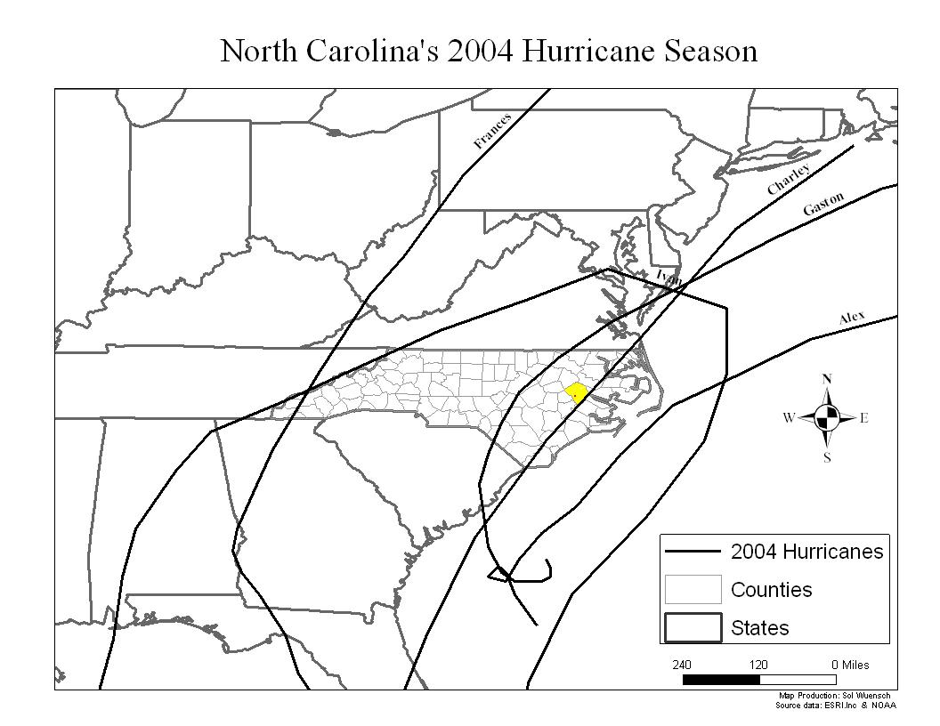
![]() Ophelia, September
2005
Ophelia, September
2005
Alberto,
June, 2006
![]()
![]() Ernesto,
September, 2006
Ernesto,
September, 2006![]() Hermine,
September, 2016
Hermine,
September, 2016![]() Matthew,
October, 2016
Matthew,
October, 2016![]() Florence,
September, 2018
Florence,
September, 2018
![]() Dorian,
September, 2019
Dorian,
September, 2019
After demolishing islands in the Bahamas, Dorian moved to a location near to but offshore of central Florida. Then it creeped north along the coast, not making landfall in the US until it hit the Outer Banks. We got little wind damage. Apples were blown off of my trees and one tree was partially blown down. We got a total of 6.3 inches of rain. At 0230 on 6-Sept-2019 our cable went out. Our power never went out. Syliva was very bummed about having no TV. I found a very old antenna, hooked it up to her TV, and managed to get her 23 digital channels. Frankly, what you get for free is pretty lame, but it is better than nothing.
![]() Isaias,
August, 2020
Isaias,
August, 2020
This Cat 1 hurricane made landfall near the North Carolina/South Carolina border. Up my way we suffered little damage from it. Some limbs were blown down, my sunchokes were blown down, but we never lost power. It was less kind to communities near where it made landfall, such as Oak Island, NC.
![]() Idalia,
August, 2023
Idalia,
August, 2023
This Cat 3 hurricane made landfall in northwestern Florida and then crossed into Georgia as a Cat 1. It was forecast to bring us flooding rains and strong wind gusts, but it spared us. We had gusts up to about 30 mph and a bit over three inches of rain.
![]() Ophelia,
September, 2023
Ophelia,
September, 2023
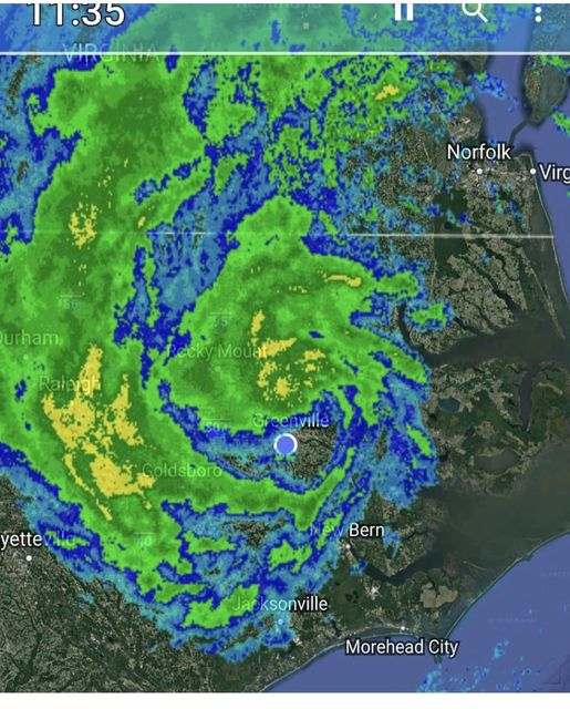
This tropical storm made landfall near Emerald Isle, NC, on 23-Sept-2023, with near-hurricane-strength winds of 70 mph. In Pitt County we had wind gust up to 40 mph, but it was primarily a rain event. We had some flooding. At our place our rain gauge overflowed, so I am not sure how much rain we got, but I am guesstimating 8 to 12 inches. The eye passed over Pitt County.

Contact Information for the Webmaster,
Dr. Karl L. Wuensch
This page most recently revised on 31-Aug-2023.