Object Descriptions Ground Floor Parlor
Map of Munster Plantation
Spenser the administrator would have taken a keen interest in the extent and progress of the Munster plantation. As a government official, he was intimately familiar with Ireland’s lawcourts, including those concerning property rights. As one of the main grantees, or “undertakers,“ of the plantation, he received over 3,000 acres of land around Kilcolman. He was himself embroiled in legal controversy over these lands, most notably with his powerful Old English neighbor, Lord Roche.
This map, contemporary to Spenser’s time on the plantation, indicates the locations of plantation holdings and their undertakers, as well as pre-existing places and lordships. The size and shape of this map indicates its origin as calf-skin, or vellum, which is stored in a folded position but is shown here hung on the wall.
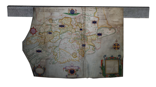
Map by Francis Jobson of the Munster Plantation (Ground Floor Parlor): courtesy of the National Library of Ireland.
For an example of a contemporary map by Francis Jobson with Spenser’s and Raleigh’s names listed on it, click here.
Literary Connections
In Spenser’s prose tract, A View of the Present State of Ireland (c. 1596), Eudoxus spreads out a map of Ireland in order to better comprehend where his partner in conversation, Irenius, wishes to place military garrisons for the defense of the realm. Such garrisons would allow the government to better control the countryside:
though perhaps I am ignorant of the places, yet I will take the map of Ireland before me and make my eyes in the meanwhile my schoolmasters to guide my understanding to judge of your plot. (View 99)
Spenser’s poetic imagination has been described as “cartographic” in many particulars, in both method and subject matter. To give only one example, after the huge dragon is killed at the climax of Book I, canto xi of The Faerie Queene, most of the rescued townspeople gather around the beast in shock and awe,
Whiles some more bold, to measure him nigh stand,
To proue how many acres he did spred of land. (FQ I.xii.11.8-9)
The killing of the dragon has close analogies with the defeat of rebels in Munster, followed by the attainder and plotting out of their lands with the help of maps.
Bibliography:
Rudolf Gottfried, “Irish Geography in Spenser’s View.” English Literary History 6.2 (1939), 114-37.
Bernard Klein, Maps and the Writing of Space in Early Modern England and Ireland (NY: Palgrave Macmillan, 2001).
Swen Voekel, “From Irish Countries to English Counties: State Sovereignty and Territorial Reorganization in Early Modern Ireland.” Archipelagic Identities: Literature and Identity in the Atlantic Archipelago, 1550-1800. Ed. Philip Schwyzer and Simon Mealor (Aldershot: Ashgate, 2004), 92-112.
William J. Smyth, Map-making, Landscapes and Memory: A Geography of Colonial and Early Modern Ireland, c. 1530-1750 (South Bend: University of Notre Dame Press, 2006).
Links:
https://folgerpedia.folger.edu/Mapping_Early_Modern_Worlds [accessed 1/30/18]
[Folger Shakespeare Library exhibit on maps]